
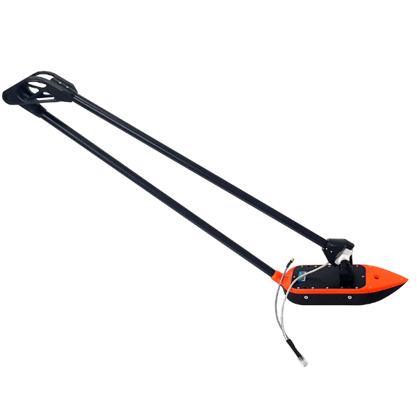
SPH – EchoNIMBUS MBES (flexible arm + Bar30 sensor)
Multibeam bathymetry system (MBES) mounted under a drone with a folding arm and Bar30 depth/pressure sensor. The EchoNIMBUS-MBES allows the generation of dense 3D point clouds for precise surveys in shallow waters and hard-to-reach areas, without a boat.
3D Bathymetry by Drone (Multibeam)
The EchoNIMBUS-MBES turns a drone into a high-resolution bathymetric survey platform. Unlike single-beam sounders (ECT), it emits 16 simultaneous beams, allowing for:
-
A dense coverage of the bottom (3D point cloud)
-
Fewer flight lines to cover an area
-
A more faithful modelling of the bottoms (banks, slopes, sediments, obstacles)
-
A faster and safer alternative to manned boats
Ideal for: reservoirs, rivers, ponds, retention basins, flooded areas, mining waste parks, and hard-to-reach sites.
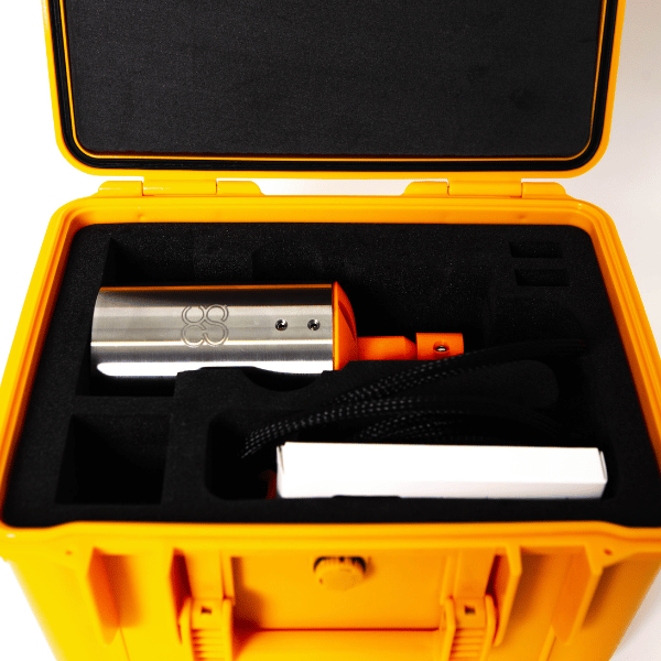
High-Performance MBES Sensor (Surveyor 240/16)
-
Acoustic frequency: 240 kHz
-
16 beams (RX array 16 elements) for better spatial resolution
-
Range: 0.5 to 50 m
-
Emitted beam width: 4° (along-track) / 80° (cross-track)
-
Received beam width: 7° (conventional beamforming)
-
Angular resolution: 1°
-
Range resolution: 0.5% of the range setting
-
Compact and lightweight design optimized for drone operations
Foldable Arm + Bar30 Sensor (Depth/Pressure)
The system is mounted on a foldable arm under the drone, facilitating:
-
Transport and deployment
-
Sensor stability in the water
-
Protection of the drone and the sensor
The Bar30 sensor (depth/pressure) provides an independent depth reference to improve the quality and consistency of measurements.
SkyHub & Real-Time Control
Integrated into the SkyHub (onboard SPH computer), the system allows:
-
Automatic and georeferenced data acquisition
-
Real-time depth measurements via UgCS Custom Payload Monitor
-
Compatibility with UgCS Expert for planning and True Terrain Following
-
Automatic recording as soon as the sensor is immersed
Processing and Output Formats
Recommended processing with BeamworX and DroneGIS, with export in:
-
CSV
-
GeoTIFF
-
LAZ (point cloud)
-
Other standard GIS formats
Optimal Operating Conditions
-
Calm to gently flowing waters
-
Stable conditions for better accuracy
-
In faster flowing rivers: zig-zag flight pattern recommended
Main Applications
-
Bathymetry of lakes, rivers, and reservoirs
-
Mining waste parks and industrial basins
-
Calculation of sediment volumes and erosion
-
Environmental and water engineering projects
-
Mapping of flooded areas and infrastructure monitoring
| Category | Specification |
| Sensor | Surveyor 240/16 |
| Type | MBES (multibeam) |
| Acoustic frequency | 240 kHz |
| Measurement range | 0.5 – 50 m |
| Transmitted beam width (TX) | 4° (along-track) / 80° (cross-track) |
| Receiver (RX) | 16 elements |
| Received beam width | 7° (conventional beamforming) |
| Angular resolution | 1° |
| Range resolution | 0.5% of setting |
| Sounder weight (air) | 1.8 kg (including folding arm) |
| Total system weight (air) | 2.4 kg (sensor + SkyHub + altimeter + cables + mounts) |
| Onboard computer | SkyHub |
| Field software | UgCS Expert |
| Data processing | BeamworX + DroneGIS |
| Export formats | CSV, GeoTIFF, LAZ, and more |
| Additional sensor | Bar30 (depth/pressure) |
- 1 × Sounder Surveyor 240/16 (EchoNIMBUS-MBES)
- 1 × Onboard computer SkyHub
- 1 × License UgCS EXPERT
- 1 × Software BeamworX (processing and point cloud)
- Power and data cables
- Mounting kit (folding arm included)
- User manual
- Bar30 depth/pressure sensor
- Training included
Recommended with this product

Shipped in 24-48hrs
Free delivery and shipped within 24/48 hours on all orders over $149 in Canada.
Secure payments
Order without fear thanks to secure payment by credit card or PayPal.
You have questions?
Enjoy a fast and certified support from our technicians.