
Pix4Dreact
2D rapid mapping for emergency response and public safety.
Fast
PIX4Dreact creates 2D maps from aerial images in a few minutes. Because when each second counts, updated and reliable information is of utmost importance to field teams.
Easy to use
Simple and intuitive use, even in complex and stressful situations. PIX4Dreact is developed with public safety and humanitarian aid professionals to meet their unique challenges.
Light and robust
Light enough to work on a mid-range computer on the ground. PIX4Dreact does not depend on an internet connection or cloud for processing.
2D orthomosaic map
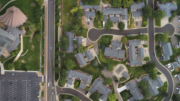
PIX4Dreact uses rapid assembly technology to create accurate 2D orthomosaic maps by combining large numbers of nadir drone images.
Markers and Measures
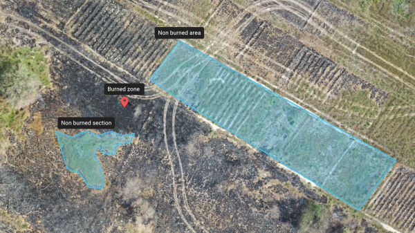
Mark areas of interest or GPS coordinates within the project and assess the situation on the ground to facilitate collaboration or long-term documentation.
Screenshots and full maps

Document and collaborate in seconds with options to export your maps as screenshots or whole maps that can be imported into PIX4Dreact on another computer.
PDF reports

Easily share a 2D orthomosaic, location data, and markers in a single file via email. Personalize the report by affixing a white label with your company's contact information and logo.
What type of software is Pix4Dreact?
Pix4Dreact is a fast 2D mapping software for emergency response and public safety.
What camera and drones for Pix4Dreact?
Pix4Dreact currently supports a wide array of cameras and drones. These are the drones available at DroneXpers that are compatible with Pix4Dreact : DJI Mini, Mavic 2 Pro, Mavic 2 Enterprise Advanced, Phantom 4 series and the Autel Evo II series.
All the official configurations can be found here.
What is the price of Pix4Dreact?
It depends of your licence type. You can purchase an annual or perpetual licence, starting at CAD $540 CAD up to $ 1370 CAD. One of our representative will assist you in the choice of the best licence for your needs.
How do I download Pix4Dreact?
You can download the software on the Pix4D website.
How do I use Pix4Dreact?
Please refer to the official Pix4Dreact documentation here.
Recommended with this product
Shipped in 24-48hrs
Free delivery and shipped within 24/48 hours on all orders over $149 in Canada.
Secure payments
Order without fear thanks to secure payment by credit card or PayPal.
You have questions?
Enjoy a fast and certified support from our technicians.