
DJI Terra
Capture, analyze and visualize your environment with DJI Terra - an easy-to-use mapping software, developed to help industry professionals transform real-world scenarios into digital assets.
DroneXperts licenses and durations:
-
DJI Terra Pro
-
DJI Terra Cluster
-
DJI Terra Electricity
* You have the choice of duration for each license.
Plan. Treat. Analyze and Execute
- Mission planning
- Data acquisition
- Area mapping
- Data analysis
Digitize the world around you
Construction
Accurately collect, measure and analyze data across projects
Infrastructure
Easily perform detailed inspections on complex assets and structures.
Energy
Safely inspect vertical assets and structures, with special optimizations for power lines.
Public security
Get a fast turnaround time for collecting critical site information.
Agriculture
Get a deep understanding of your field to help you achieve better yields.
Film
Optimize previewing to improve planning workflows across your team.
Effectively plan your missions (flight routes)
Mission planning by waypoints
Create efficient flight paths using predefined waypoint actions and adjustable parameters such as altitude, speed, gimbal pitch angle, aircraft heading and more. For more complex and tight missions that require high attention to detail, use 3D flight visualization to design and simulate tasks on existing 3D models.
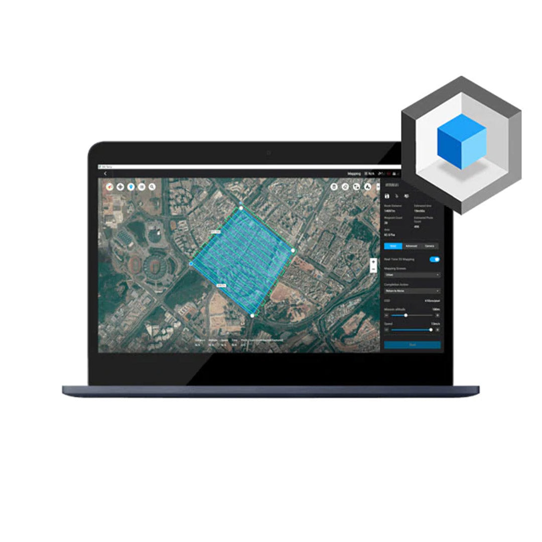
Area Mission Planning
With just a few taps of the screen, you can automate complex missions, allowing you to seamlessly capture images that can be processed to produce a variety of maps and models for further analysis and to assist in taking decision.
Oblique mission planning
When precision is essential and details are vital to your critical operations, Oblique allows you to capture a rich set of 3D model data by adjusting the camera angle to a tilted angle, giving you an extra sharp view of the asset.
Corridor Mission Planning
Create automated flight missions around roads and railways by simply drawing a line on the map. Adjust mission settings to change the total area mapped, giving you the flexibility to choose between creating high-definition 2D maps and 3D models or quick overviews.
Detailed planning of the inspection mission
Automatically generate waypoints and flight routes based on one or more selected points in a local 3D model or point cloud (or third-party point cloud). A simulated camera view including the selected point is displayed on screen to enable better waypoint selection and more efficient flight route planning, which automates inspection workflows.
Smooth workflows, precise results
Unmatched efficiency and user experience
Import images with ease while effortlessly navigating the intuitively designed interface. Bulk process up to 400 images/1 GB RAM, reducing wait time between field work and digital visualization. Run rebuilding missions using multiple graphics cards simultaneously to improve efficiency.
Meet and exceed your project standards
3D models with improved absolute accuracy by defining ground control points (GCP) and control points, so you can measure and inspect with ease. View a quality report of your engagement to ensure the results meet your accuracy standards.
Compatibility and flexibility
Convert coordinates from your maps and models to over 8500 major coordinate systems by simply selecting the output that suits your needs.
Incorporate POS data, GCPs, or both datasets to create georeferenced maps and models with increased accuracy directly in the target coordinate system required by the project.
Mapping
2D maps
Real-time mapping
Quickly generate a 2D orthomosaic of the selected area in real time. This feature is not only ideal for creating detailed flight paths in remote areas, but it is also useful for time-sensitive missions that require rapid on-the-spot decision-making.
2D reconstruction
Generate high-resolution orthomosaics, allowing you to obtain detailed and accurate measurement results for all your critical projects.
2D multispectral reconstruction
Using multispectral data from P4 Multispectral, generate radiometrically calibrated reflectance maps for remote sensing research and more, or produce vegetation index maps including NDVI and NDRE. Create prescription maps for variable rate application using DJI Agras drones to improve crop yield while reducing costs.
3D models
Real-time 3D mapping
When efficiency is essential, quickly render and visualize a 3D model of the mapped area. Make decisions based on the preliminary model and immediately check its completeness or plan 3D flights on site.
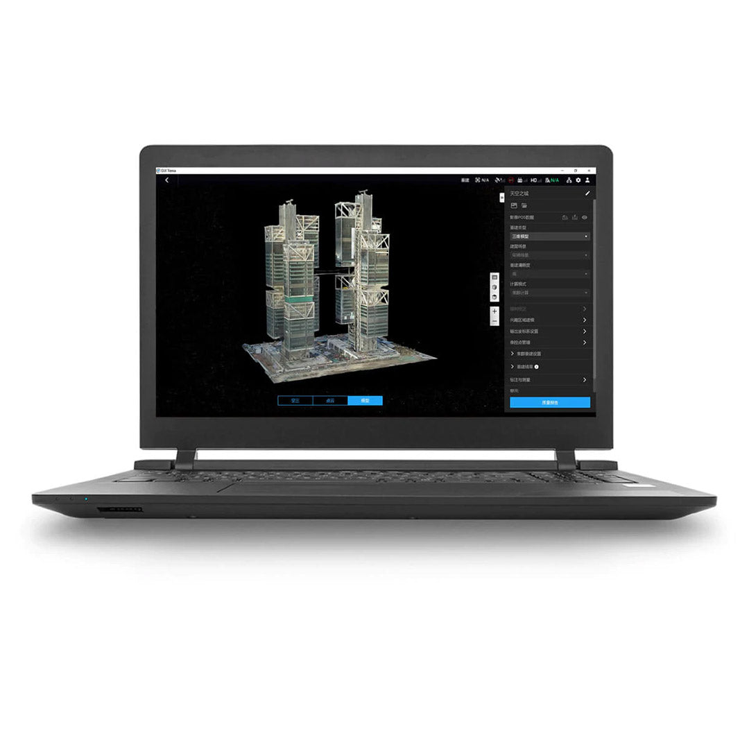
3D reconstruction
Get sharp, realistic representations of your environment in a variety of industrial applications, from accident reconstruction, to recreating thin power lines and complex vertical structures, to managing large construction projects, and more . CUDA-based reconstruction algorithms are capable of quickly processing large amounts of data to provide quality results.
With the region of interest feature, image reconstruction can be performed on a specific target region. This saves processing time and improves efficiency, while generating a clearer model or point cloud.
LiDAR data processing
Point cloud data processing
Process point cloud data captured by the Zenmuse L1 in DJI Terra. With just one click, calculate POS data, merge point cloud and visible light data, export point clouds in standardized formats, and generate field reports.
Data analysis and processing
2D and 3D measurements
Obtain key dimensions across a wide range of terrain with DJI Terra's easy-to-use analysis tools that allow you to obtain a variety of measurement data based on linear, area, and volumetric measurements.
Annotation
Edit metric labels on existing templates, which can be used for reporting and improving communication throughout ongoing projects.
Photo inspection
Examine each photo of the model carefully so you can spot and highlight critical elements in the real world.
The beginning of next generation mapping solutions
Harness the power of AI-driven mapping solutions designed to take your industrial projects to the next level. From object classification to site inspections and more, you can start developing task-specific mapping solutions to complete your missions seamlessly.
Data acquisition
Define the mission objective, plan the desired flight plan, and with the press of a few buttons, autonomously collect critical data to achieve the desired result.
Data processing
Use refined image recognition technology to generate 2D and 3D data, resulting in a more realistic representation of your assets, objects, surroundings and more.
Data Application
Implement machine learning tools and techniques, which can be used in a variety of different industries - such as classification algorithms to identify trees, objects and other scenarios.
Execution
Take the necessary steps and enjoy more efficient processes with machine control, whether it's automated crop spraying, job site monitoring, material transportation, and more.
What are the computer system requirements for 2D and 3D reconstruction with DJI Terra?
A Windows 7 or higher (64-bit) system and the necessary hardware requirements are required to use the DJI Terra.
Autonomous calculations:
Minimum System Requirements: 32G RAM, 4G Graphics RAM (NVidia graphics computing power must be shader model 3.0 or better).
Recommended system requirements: 64G of RAM or more. NVidia 2070 or higher graphics card.
When the configuration conditions are met, each additional 10G of free memory can process 4,000 more photos. More advanced configurations will process more photos and reconstruct them faster. Different hardware configurations will have no impact on the results of the generated model.
Cluster calculation:
Contact us before using DJI Terra for more information on setting up a device.
DJI Terra License (may vary depending on your product choice and license term)
Which DJI Terra drone models currently support route planning?
Phantom 4 RTK (remote control), Phantom 4 Pro V2.0, Phantom 4 Pro+ V2.0, Phantom 4 Pro, Phantom 4 Advanced and Phantom 4. The Phantom 4 does not support 2D real-time mapping.
Which drone supports real-time 3D mapping?
Phantom 4 RTK (remote control), Phantom 4 Pro V2.0, Phantom 4 Pro + V2.0. Note: Models may be of poor quality or unavailable in environments without RTK signals.
Which drone models are supported by detailed inspection flight path planning?
Phantom 4 RTK, Matrix 300 RTK + H20 Series Payloads, Mavic 2 Enterprise Advanced
Shipped in 24-48hrs
Free delivery and shipped within 24/48 hours on all orders over $149 in Canada.
Secure payments
Order without fear thanks to secure payment by credit card or PayPal.
You have questions?
Enjoy a fast and certified support from our technicians.